
Circuito Netuno de Travessias 2026 — Etapa 2 (São Vicente)
- Mar 29, 2026
- Last edition date
- Distances from 750m to 3km
At a glance
- Last edition date
- March 29, 2026
- Distances
- 750 m · 1.5 km · 3 km
- Where
- Sea · Praia do Itararé, São Vicente, São Paulo, Brazil
- Entry fee
- 170 BRL
- Registration
- ypseventos.com.br
About the race
The broad ocean crescent of Praia do Itararé stretches beneath Ilha Porchat, framing a multi-distance swim in the historic bay of São Vicente. Here on the south coast of São Paulo, the Circuito Netuno de Travessias — Etapa 2 (São Vicente) draws swimmers into open sea waters that have greeted ocean mariners for over five centuries. The event forms an integral chapter of the regional Netuno open-water circuit organized by YPS Promoções e Eventos, gathering athletes on the sands. The start line unfolds along the shoreline of Praia do Itararé, extending into neighboring Praia dos Milionários in São Vicente. Itararé is an expansive beach that runs for 2.9 kilometers from the base of Ilha Porchat all the way to Canal 1.

The tidal dynamics here are remarkable: depending on the season and the state of the tide, the distance from the dry sand edge down to the breaking surf can exceed 150 meters, leaving a vast, flat arena of hard-packed sand to cross before diving into the swell. Once past the shorebreak, the swim course opens up across the open sea. Rising just offshore directly in front of the swimming line stands the uninhabited islet of Urubuqueçaba, providing an unmistakable natural landmark to site against while settling into your stroke. Swimmers can take on courses tailored to various levels of sea-swimming experience, with three distances of 750 meters, 1,500 meters, and 3,000 meters. Held in late March as the Southern Hemisphere transitions into autumn, the event offers inviting water and sweeping ocean beaches.
Race day at Praia dos Milionários
The official rules of the Circuito Netuno de Travessias name Praia dos Milionários as the venue of every stage in São Vicente, with Ilha Porchat Clube as the address reference. Timing is by Cronotime, and every swimmer wears an electronic chip on the ankle for the whole swim and hands it back after the finish. Praia dos Milionários is a narrow stretch of shoreline right by the rocks of Ilha Porchat, and just across Alameda Paulo Gonçalves the sand of Praia de Itararé begins. The beach is known for a usually calm sea and for a view that runs across the bay. Its name Milionários refers to the old habit of motorboat owners stopping at this spot for a swim.
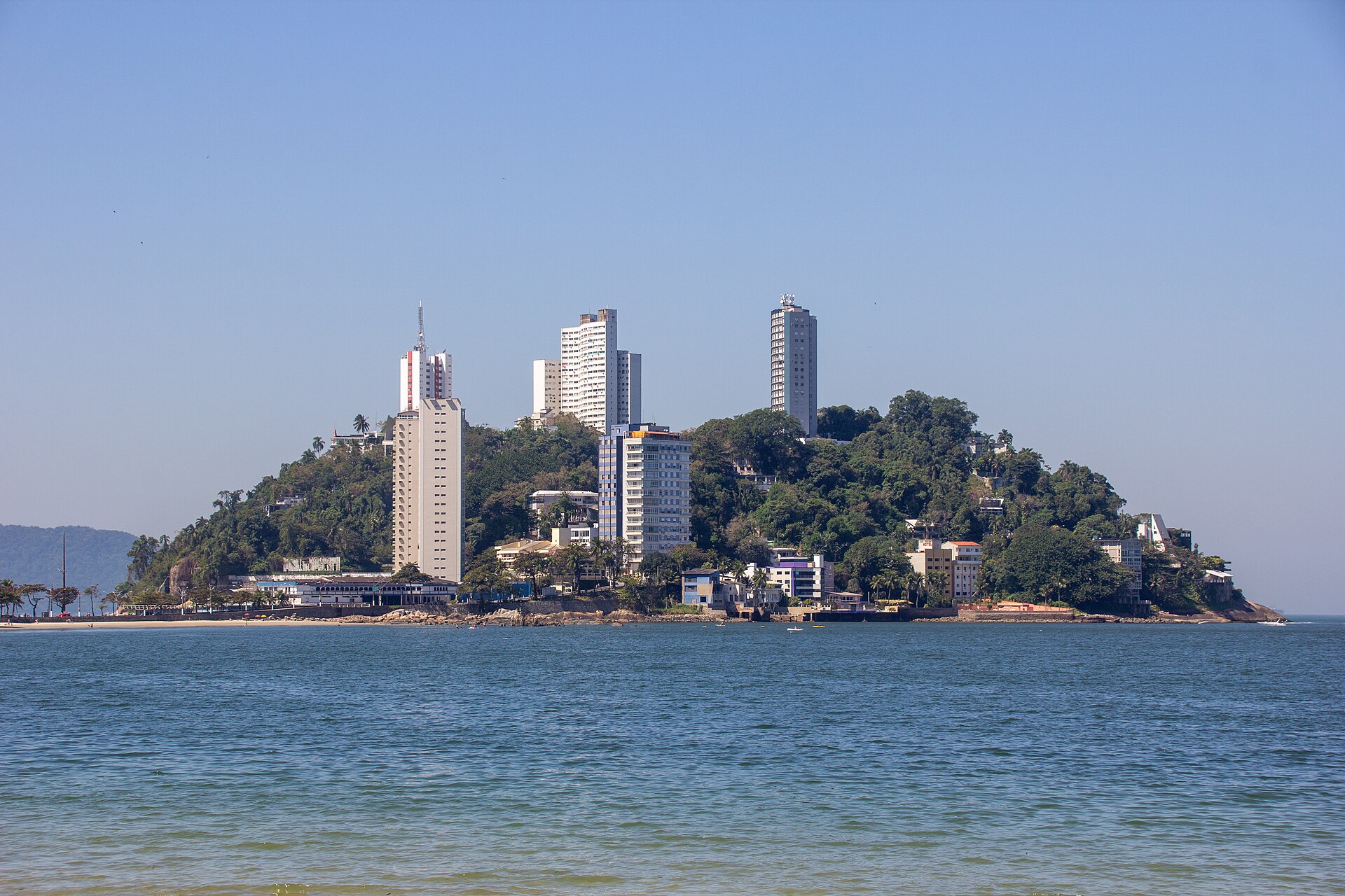
Ilha Porchat: from colonial landmark to Niemeyer lookout
Anchoring the western flank of the beach is Ilha Porchat, a rocky promontory that was historically a true tidal island, isolated from the mainland of São Vicente only during high water. Because of its commanding position at the entrance of São Vicente Bay, the headland served for generations of navigators as a crucial geographical landmark. In centuries past, its rocky slopes were completely blanketed by dense Atlantic tropical rainforest, plunging directly into the sea. During the late eighteenth century, local mariners referred to the headland as Ilha das Cobras. While that old name recalled the untamed thickets of the coast, the islet was quickly transformed by early settlers: by the opening decade of the nineteenth century, it had been repurposed as goat pasture and renamed Ilha das Cabras.
At the summit of Ilha Porchat stands a soaring concrete monument, inaugurated in 2002 to commemorate the 500th anniversary of the Portuguese arrival in Brazil. The minimalist arch frames the skyline, functioning as one of the best vantage points on the coast. From its crest, visitors and returning swimmers can look out across the entire 2.9-kilometer sweep of Praia do Itararé, surveying the race line, the offshore islet of Urubuqueçaba, and the deep blue expanse of Santos Bay.
Raiders, armadas, and sunken ships in Santos Bay
Long before European ships sighted these waters, the island of São Vicente was known as Gohayó by its original Tapuia inhabitants, who were later displaced by the Tupi around the year 1000. Navigators Gaspar de Lemos and Amerigo Vespucci arrived off the coast on January 22, 1502, christening the area in honor of Saint Vincent of Saragossa and placing São Vicente on world maritime maps. Three decades later, in December 1531, Martim Afonso de Sousa anchored his colonizing fleet just across the bay in front of Praia do Góis. The open anchorages of the bay soon attracted foreign corsairs and naval battles. In December 1591, the English privateer Thomas Cavendish raided the coastal settlements, looting homes and torching parts of the village of São Vicente.
A generation later, in 1615, Dutch commander Joris van Spielbergen brought his fleet into the bay, briefly capturing the local sugar mill before determined residents rallied and drove the invaders back out to sea. The approaches to São Vicente and Santos have also claimed merchant vessels over the centuries, turning the seafloor into a graveyard of maritime relics. In February 1895, the British wooden barque Kestrel dragged its anchor during a fierce tropical storm and ran hard aground on Boqueirão Beach, about five kilometers down the coast. Buried for over a century, the timbers of the wreck resurfaced on nearby Embaré Beach in August 2017 after heavy surf eroded coastal sand, with its bow still pointed straight across the bay towards São Vicente.
Xixová-Japuí State Park: coastal rainforest and hidden springs
Directly behind the sands of Itararé rises Voturuá Hill, locally known as Asa Delta Hill, whose steep crest offers sweeping vistas over São Vicente and Santos and can be reached via a cable car running straight from the beach promenade. Down on the sand, visitors encounter the Pedra da Feiticeira, a weathered coastal boulder long surrounded by local folklore and maritime legends. Just four kilometers from the race area, the protected wilderness of Xixová-Japuí State Park preserves a pristine stretch of the Atlantic Forest ecosystem, established by decree in September 1993. Tucked behind Xixová Hill and sheltered beneath Itaipu Peak lies Praia de Itaquitanduva, a secluded 300-meter pocket of wild coastline entirely untouched by urban development.
Unlike the wide urban beaches, this hidden inlet feels secluded and timeless, cradled by emerald forest on all sides. A natural spring of fresh, potable water cascades down from the hill directly onto the sands of Itaquitanduva, providing water in the middle of coastal wilderness. The reserve serves as a sanctuary for environmental research, sheltering native flora, diverse wildlife, and migratory birds that rest along the headland during their seasonal journeys. Swimming the waters of São Vicente places you right against this living balance, where centuries of maritime tradition meet the wild forested headlands of the Brazilian coast.
Sources: Ilha Porchat · Praia do Itararé · São Vicente Island (São Paulo, Brazil)
Course
Open water swimming event held at Praia dos Milionários, São Vicente.
Open water swimming event held at Praia dos Milionários, São Vicente.
Open water swimming event held at Praia dos Milionários, São Vicente.
How to get there
Circuito Netuno de Travessias 2026 — Etapa 2 (São Vicente)
Frequently asked questions
- When was the last edition of Circuito Netuno de Travessias 2026 — Etapa 2 (São Vicente)?
- The last edition of Circuito Netuno de Travessias 2026 — Etapa 2 (São Vicente) took place on March 29, 2026.
- What distances does Circuito Netuno de Travessias 2026 — Etapa 2 (São Vicente) offer?
- Circuito Netuno de Travessias 2026 — Etapa 2 (São Vicente) offers 750 m, 1.5 km, and 3 km.
- How much is the entry fee for Circuito Netuno de Travessias 2026 — Etapa 2 (São Vicente)?
- The entry fee is 170 BRL. Price for the 18th Circuito Netuno de Travessias 2026 (Stage 2 - São Vicente). The value varies by batch and chosen kit (Silver Kit: R$ 150 / 160 / 170; Gold Kit: R$ 175 / 185 / 195).
- Where does Circuito Netuno de Travessias 2026 — Etapa 2 (São Vicente) take place?
- Circuito Netuno de Travessias 2026 — Etapa 2 (São Vicente) is a sea swim. Location: Praia do Itararé, São Vicente, São Paulo, Brazil.
- How do I register for Circuito Netuno de Travessias 2026 — Etapa 2 (São Vicente)?
- The reference page for registering for Circuito Netuno de Travessias 2026 — Etapa 2 (São Vicente) is https://www.ypseventos.com.br.
Where to stay
Accommodations in São Vicente range from practical beachfront apartments to traditional guesthouses located near the historic center. Budget-conscious swimmers often look for 'kitnets' (studio apartments) near Praia do Itararé, while those preferring more comfort opt for hotels along the main promenade. Expect nightly rates to fluctuate significantly based on proximity to the water, typically ranging from $40 to $120 USD per night for standard double occupancy during the off-peak season.
Things to do nearby
The weekend offers a mix of urban exploration and nature. Visitors can tour the historic sites related to the 1532 settlement, including the iconic stone markers at Praia do Gonzaguinha. For those seeking active recovery, the local coastline provides excellent conditions for SUP and kayaking, particularly around the calmer inlets shielded by the rocky outcrops. Gastronomy enthusiasts should explore the local 'quiosques' along the shore, which serve fresh regional catches and traditional coastal appetizers, offering a true taste of the São Paulo maritime culture.
Swimmers
Other stages of this series
- Circuito Netuno de Travessias — Etapa 5 (São Vicente)São Vicente, BR
- Circuito Netuno de Travessias — Etapa 6 (São Vicente)São Vicente, BR
- Circuito Netuno de Travessias 2026 — Etapa 1 (São Vicente)São Vicente, BR
- Circuito Netuno de Travessias 2026 — Etapa 3 (São Vicente)São Vicente, BR
- Circuito Netuno de Travessias — Etapa 4 (São Vicente)São Vicente, BR
Similar races


Comments
Transparency: some links on this page (stays, flights, experiences, gear) are affiliate links — if you book or buy through them, Omniathlon may earn a commission from the partner at no extra cost to you. As an Amazon Associate we earn from qualifying purchases.