
Circuito Netuno de Travessias 2026 — Etapa 3 (São Vicente)
- May 10, 2026
- Last edition date
- Distances from 750m to 3km
At a glance
- Last edition date
- May 10, 2026
- Distances
- 750 m · 1.5 km · 3 km
- Where
- Sea · Praia do Itararé, São Vicente, São Paulo, Brazil
- Entry fee
- 150 BRL
- Registration
- ypseventos.com.br
About the race
On the sands of Praia do Itararé, swimmers gather where the coastal city meets the open ocean. The Circuito Netuno de Travessias 2026 — Etapa 3 (São Vicente) is an open water swimming race in the Atlantic sea waters of São Vicente, in the state of São Paulo, Brazil. The race takes place along the Atlantic shoreline, drawing swimmers to the waterfront sands of Praia do Itararé and Praia dos Milionários. The event is organized by YPS Promoções e Eventos, with institutional support provided by the Prefeitura Municipal de São Vicente. Swimmers can choose between three distinct distances in the sea: 750 meters, 1,500 meters, and 3,000 meters. Stepping across the tideline, competitors head into the ocean chop, navigating around turn buoys under open skies.

Conditions can vary from gentle morning swells to challenging sea states. In a past edition of the third stage, bright sunshine framed the event, but dry cold, continuous wind, and rough waters nearly prevented the competition from taking place. Confronted with those demanding sea conditions, the organizers decided to shorten the swimming course to 750 meters, ensuring that every participant could complete their race safely in the water.
Ilha Porchat and the tidal bay of São Vicente
Praia do Itararé extends for 2.9 kilometers from Ilha Porchat to Canal 1. The beach is marked by a massive tidal shift: depending on the time of year and the movement of the tide, the distance from the shoreline to the water can exceed 150 meters. At low tide, this vast expanse of wet sand turns into an expansive staging ground where swimmers run through the shallows before plunging into swimming depth. At one end of the beach rises Ilha Porchat, a tidal island that historically separated from the main island of São Vicente only during high tide. Because of its prominent position, the island long served as a strategic geographical landmark at the entrance to the Bay of São Vicente.
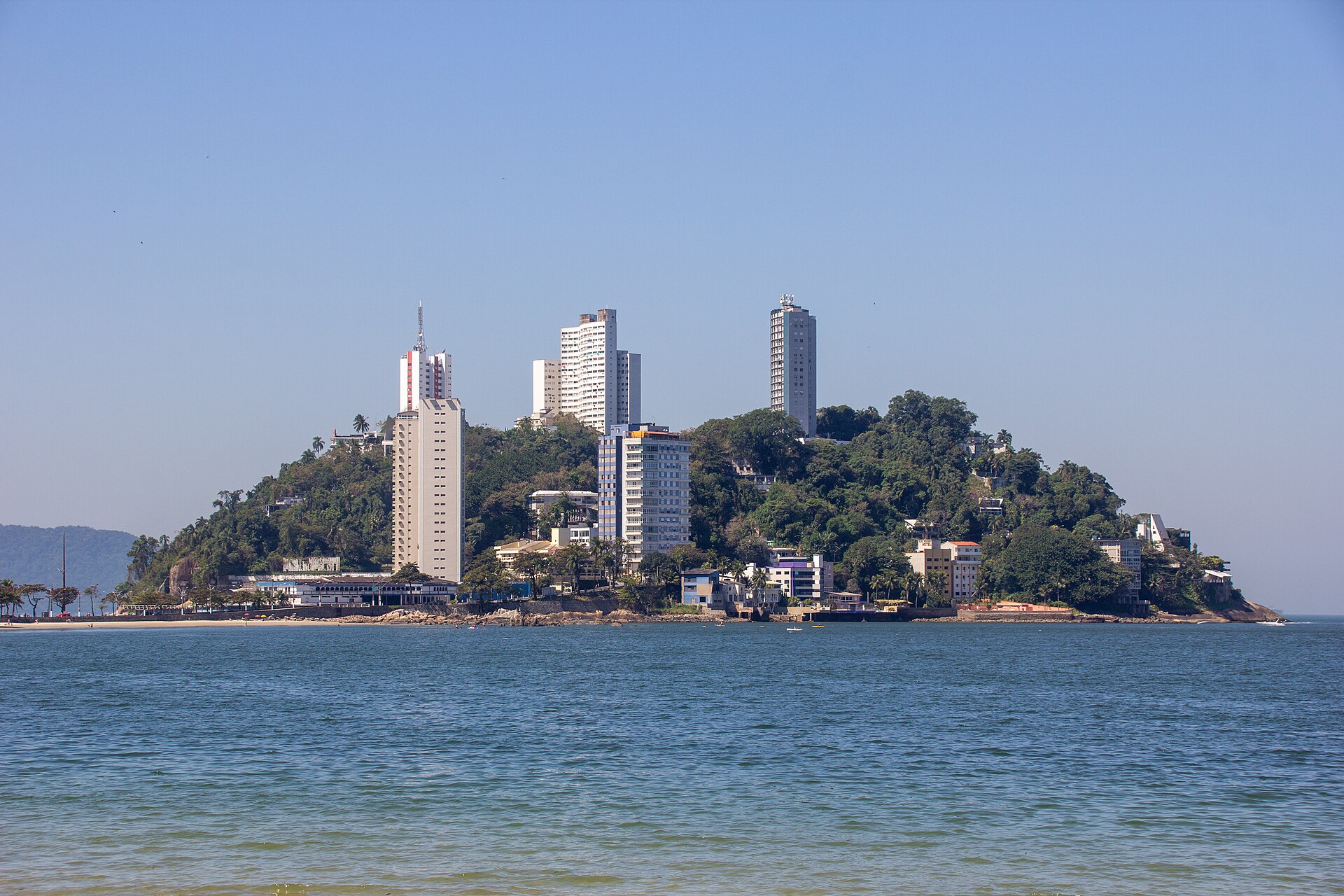
Historically, the steep slopes of the promontory were covered by dense tropical vegetation. In the late eighteenth century, the headland was known as Ilha das Cobras. After the first decade of the nineteenth century, it became known as Ilha das Cabras because goats were farmed along its slopes. Just off the sands of Itararé, the uninhabited island of Urubuqueçaba rises directly out of the sea only a few meters in front of the beach. From the Niemeyer Monument on Ilha Porchat, spectators and swimmers can look down across the entire arc of Praia do Itararé and take in panoramic views over the Bay of Santos.
São Vicente Island: Portuguese armadas, tsunamis, and pirates
The race waters border the island of São Vicente, which encompasses a total land area of 57.4 square kilometers. The island is bounded by the open Atlantic ocean on one side and by freshwater rivers along its remaining borders. Originally known as Gohayó, the island was settled by the Tapuia indigenous people until they were driven out by the Tupi around the year 1000. Navigators Gaspar de Lemos and Amerigo Vespucci reached the island on January 22, 1502, bestowing the name São Vicente in honour of Saint Vincent of Saragossa. In December 1531, a royal Portuguese colonizing fleet led by Martim Afonso de Sousa anchored its ships off Praia do Góis.
Praia do Góis is a 250-meter-long beach inhabited primarily by fishermen, tucked between hills carpeted in Atlantic forest and characterized by calm waters. Next to it lies Sangava beach, an inlet featuring clear, calm water without waves or currents, where natural pools sit embedded among coastal rocks, though its shoreline deepens abruptly into deep water. In late 1541, a giant ocean wave, believed to have been a tsunami, wiped out the coastal village, forcing the port and township to be relocated and reconstructed further away from the sea. Settlers developed early industries, including the historic sugarcane processing mill known as Engenho dos Erasmos. English pirate Thomas Cavendish pillaged and set fire to parts of São Vicente in December 1591.
In 1615, Dutch privateer Joris van Spielbergen attacked the settlement and occupied the local sugar mill before being driven away by the inhabitants. To deter future incursions, a small defensive fort was erected at Praia do Góis to support the nearby Fortaleza de Santo Amaro da Barra Grande and prevent hostile ships from entering the Bertioga channel.
The Santos bar shipwrecks and nearby shores
On February 11, 1895, the anchor chain of the British barque Kestrel snapped during a severe tropical storm, causing the vessel to run aground on Boqueirão Beach, about five kilometers from the race area. The disaster came only a year after two other vessels, the Elitel Fritz and the Madonna Della Costa, had run aground on the very same stretch of coast in 1894. On August 22, 2017, storm erosion on Embaré Beach near Canal 5 re-exposed the wooden hull of an old shipwreck, oriented with its stern right against Canal 5 and its bow facing towards São Vicente. The rediscovery revealed the long-term impact of coastal infrastructure: approximately 1.5 meters of sand had been removed from the beach since the original construction of Canal 5 in 1927.
Further out at sea, about five kilometers from the race area on the Santos bar near Ilha das Palmas, lies the shipwreck of the SS Guararema. The steamship sank on March 4, 1949, after colliding with the steamship Britannia, and its remains rest on the seabed at the coordinates 23°59′54″S 46°19′30″W. Praia do Guaiúba spans approximately 790 meters, covered in fine, light-colored sand. Nearby, nestled between Praia do Guaiúba and Praia das Astúrias, lies Praia do Tombo, which extends for roughly 900 meters. There, the geological formation creates powerful breakers and a relatively rough sea with multiple drop-offs and holes along the sandy floor, illustrating the dynamic surf that characterizes this coastline.
Morro do Voturuá and the Xixová-Japuí coastal reserve
Directly overlooking the sands of Praia do Itararé stands Morro do Voturuá, also known as Asa Delta Hill. The promontory offers sweeping vistas over the surrounding cities and can be reached via a cable car operating right from Itararé Beach. Swimmers and beachgoers encounter Pedra da Feiticeira, a prominent local landmark steeped in centuries of folklore. Roughly four kilometers from the race area, the coastal environment is protected by the Xixová-Japuí State Park, established by government decree on September 27, 1993. Hidden behind Xixová Hill and resting directly under Itaipu Peak is Praia de Itaquitanduva, an isolated sandy beach extending for 300 meters. A natural spring of drinkable fresh water flows straight off the hillside and empties across the sand. Because of its pristine habitat, this protected coastal pocket is used for scientific research into native flora, resident wildlife, and migratory birds.
Sources: Ilha Porchat · Praia do Itararé · São Vicente Island (São Paulo, Brazil)
Course
Open water swimming event held at Praia dos Milionários, São Vicente.
Open water swimming event held at Praia dos Milionários, São Vicente.
Open water swimming event held at Praia dos Milionários, São Vicente.
How to get there
Circuito Netuno de Travessias 2026 — Etapa 3 (São Vicente)
Frequently asked questions
- When was the last edition of Circuito Netuno de Travessias 2026 — Etapa 3 (São Vicente)?
- The last edition of Circuito Netuno de Travessias 2026 — Etapa 3 (São Vicente) took place on May 10, 2026.
- What distances does Circuito Netuno de Travessias 2026 — Etapa 3 (São Vicente) offer?
- Circuito Netuno de Travessias 2026 — Etapa 3 (São Vicente) offers 750 m, 1.5 km, and 3 km.
- How much is the entry fee for Circuito Netuno de Travessias 2026 — Etapa 3 (São Vicente)?
- The entry fee is 150 BRL. Prices valid for the 2026 edition. Silver Kit: 1st Batch R$ 150.00, 2nd Batch R$ 160.00, 3rd Batch R$ 170.00. Gold Kit: 1st Batch R$ 175.00, 2nd Batch R$ 185.00, 3rd Batch R$ 195.00. Service fee not included.
- Where does Circuito Netuno de Travessias 2026 — Etapa 3 (São Vicente) take place?
- Circuito Netuno de Travessias 2026 — Etapa 3 (São Vicente) is a sea swim. Location: Praia do Itararé, São Vicente, São Paulo, Brazil.
- How do I register for Circuito Netuno de Travessias 2026 — Etapa 3 (São Vicente)?
- The reference page for registering for Circuito Netuno de Travessias 2026 — Etapa 3 (São Vicente) is https://www.ypseventos.com.br.
Where to stay
São Vicente offers a range of stays, from functional apartments near the boardwalk to mid-range hotels along the coast. Expect to find simple guesthouses and modern flats within walking distance of the race start. Prices typically range from $40 to $90 per night, depending on proximity to the oceanfront and the level of amenities provided. The area is well-connected to neighboring cities, allowing for diverse lodging options that suit both solo travelers and those visiting for the sport.
Things to do nearby
Beyond the water, the region provides access to the Xixová-Japuí State Park, which offers trails through the Atlantic Forest. Visitors often explore the local history through the commemorative sites marking the 1532 settlement or take advantage of the calmer waters of the bay for stand-up paddleboarding. For those interested in local culture, the area features various activities and tours that highlight the maritime history and natural landscape of the São Paulo coast.
Swimmers
Other stages of this series
- Circuito Netuno de Travessias — Etapa 5 (São Vicente)São Vicente, BR
- Circuito Netuno de Travessias — Etapa 6 (São Vicente)São Vicente, BR
- Circuito Netuno de Travessias 2026 — Etapa 1 (São Vicente)São Vicente, BR
- Circuito Netuno de Travessias 2026 — Etapa 2 (São Vicente)São Vicente, BR
- Circuito Netuno de Travessias — Etapa 4 (São Vicente)São Vicente, BR
Similar races


Comments
Transparency: some links on this page (stays, flights, experiences, gear) are affiliate links — if you book or buy through them, Omniathlon may earn a commission from the partner at no extra cost to you. As an Amazon Associate we earn from qualifying purchases.