
Circuito Netuno de Travessias — Etapa 5 (São Vicente)
- Nov 15, 2026
- Distances from 750m to 3km
At a glance
- Next edition date
- November 15, 2026
- Distances
- 750 m · 1.5 km · 3 km
- Where
- Sea · Praia dos Milionários, São Vicente, São Paulo, Brazil
- Entry fee
- 150 BRL
- Registration
- ypseventos.com.br
About the race
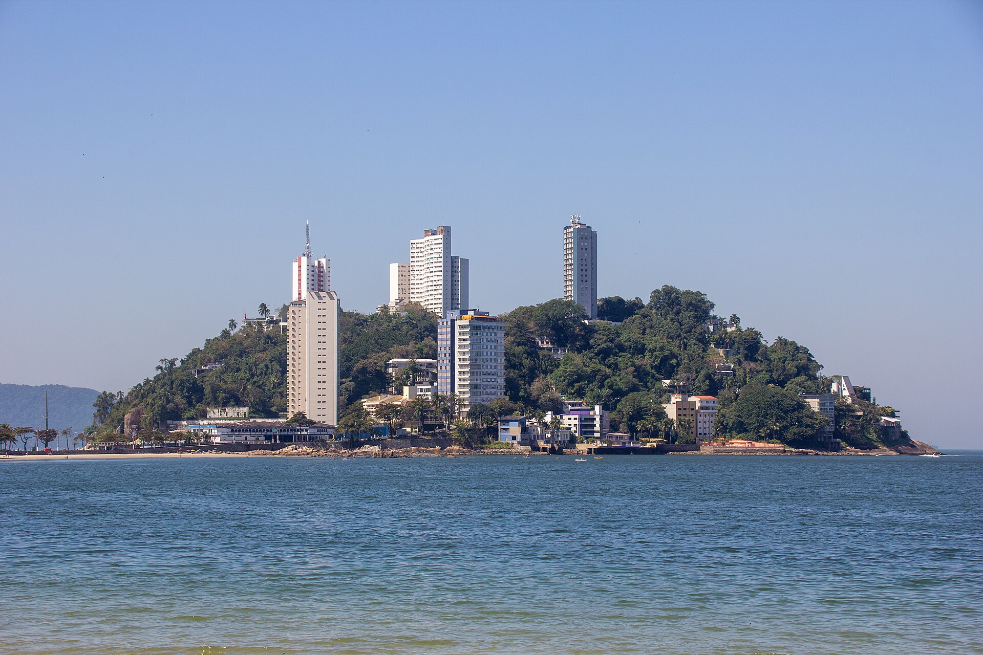
Beside the rising headland of Ilha Porchat, the sea opens along Praia dos Milionários in the municipality of São Vicente. The Circuito Netuno de Travessias — Etapa 5 (São Vicente) is an open water swimming race held in the sea off Praia dos Milionários, on the coast of São Paulo in Brazil. Held in November, the event gathers swimmers along this historic shoreline of São Vicente Island. Standing on the sand before the call to the start line, competitors read the surface conditions and prepare for a direct ocean course. The competition program provides three open water courses: 750 meters, 1,500 meters, and 3,000 meters. These options cater to both sprinters looking for a fast coastal outing and endurance swimmers seeking a sustained challenge in open water.
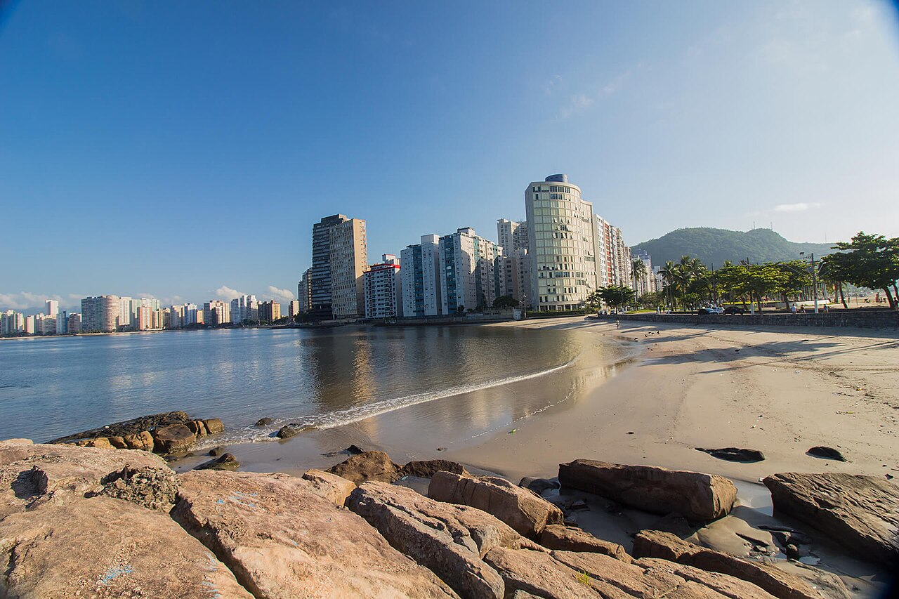
The event is organized by Yps Promoções e Eventos. From the starting horn, swimmers enter the sea from the beach, navigate the turning buoys set across the water, and push through the breakers on their return to the timing mats.
How the Netuno circuit works: calendar, age groups and points
The 2026 Circuito Netuno has six stages, all held at Praia dos Milionários in São Vicente, with Ilha Porchat Clube given as the address reference. Stages at Praia dos Milionários fall on 15 November and 20 December 2026, and the final on 24 January 2027. The 750 m has Kids A for ages 8 to 12 and Kids B for ages 12 to 14, followed by beginner classes starting at 15 to 19 years. The 1500 m and 3000 m are split into five-year age bands starting at 15 to 19, 20 to 24 and 25 to 29, with a Triathlon Open class alongside. Circuit points run from 127 for first place to 107 for second, 99 for third, 93 for fourth and 89 for fifth. To contest the championship an athlete must race at least five of the six stages, and anyone who races all six drops the worst result.
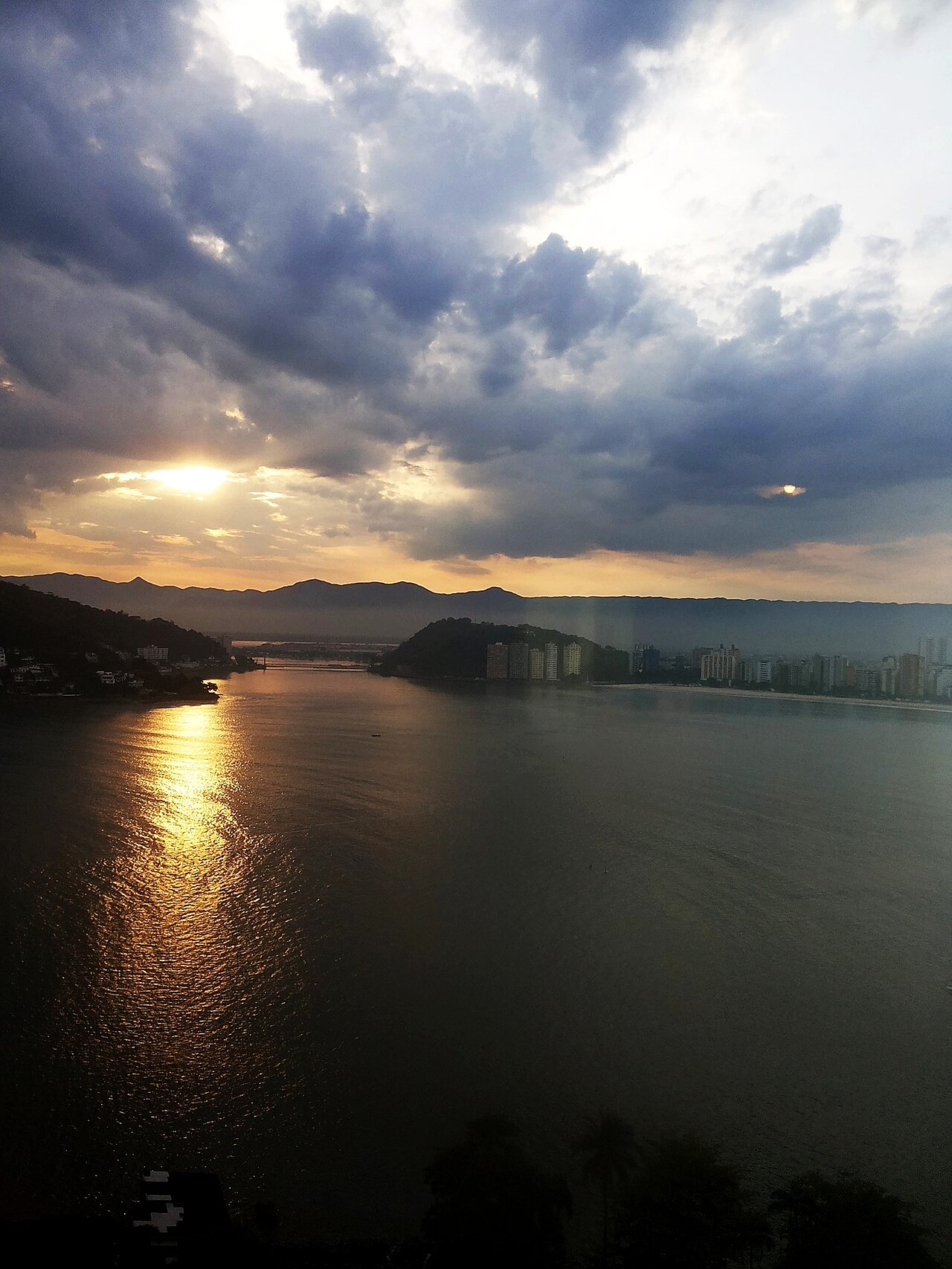
Ilha Porchat and the waters of São Vicente Bay
The municipality of São Vicente is situated on the western half of São Vicente Island. This island covers an area of 57.4 square kilometers and is bordered by the open ocean on one side and freshwater rivers on its other boundaries. Emerging from the south of São Vicente Island, Ilha Porchat forms an islet that stands nearly 70 meters high. Historically covered in dense tropical vegetation, it was once a tidal island that became separated from the main island only during high tide. Because of its commanding profile at the entrance of the Bay of São Vicente, the headland long served as a strategic navigational landmark. In 2002, an arch-shaped monument designed to commemorate the 500th anniversary of the discovery of Brazil was inaugurated atop Ilha Porchat.
From this Niemeyer Monument, visitors can gaze across the entire expanse of Praia do Itararé and the wide Bay of Santos. Down on the sand, Praia dos Milionários provides a view across the Bay of São Vicente and toward the landmark Suspension Bridge. Around the curve of the point, Praia do Itararé stretches along the coast for 2.9 kilometers between Ilha Porchat and Canal 1. Depending on the season and the movement of the tide, the distance across Itararé from the seawall to the water can exceed 150 meters.
São Vicente: colonial fleet anchorages and naval battles
São Vicente was formally established as a permanent settlement in 1532 at a coastal site previously known as the Port of the Slaves. The island features the Engenho dos Erasmos, an early sugar cane facility. In December 1531, a colonizing expedition commanded by Martim Afonso de Sousa anchored its ships opposite Praia do Góis, across the channel. A small defensive fort was later erected at Praia do Góis to support the Fortaleza de Santo Amaro da Barra Grande and prevent hostile ships from entering the Bertioga channel. On February 3, 1583, a naval battle took place off São Vicente between three English warships and three Spanish galleons, which ended in the sinking of one Spanish vessel.
In the late 18th century, Ilha Porchat was known as Ilha das Cobras. By the early 19th century, following the introduction of goat herds across its slopes, the headland was known as Ilha das Cabras. About five kilometers from the race area, the maritime past has left several shipwrecks scattered across the coastal seabed. On March 4, 1949, the steamship Guararema sank on the Santos bar near Ilha das Palmas after colliding with the steamship Britannia, coming to rest at coordinates 23°59′54″S 46°19′30″W.
Shipwrecks often transform into underwater habitats colonized by octopuses and crustaceans. In 1894, two other vessels, the Elitel Fritz and the Madonna Della Costa, also ran aground in that same coastal stretch. Following storm erosion on Embare Beach near Canal 5 on August 22, 2017, the buried hull of a wooden shipwreck was exposed with its stern beside the canal and its bow directed toward São Vicente, in a sector where some 1.5 meters of sand had been removed since 1927.
Xixová-Japuí State Park: the wild southern coastline
The Xixová-Japuí State Park encompasses 901 hectares of preserved nature established by state decree on September 27, 1993. Sheltered inside the park, Praia de Itaquitanduva sits secluded behind the Xixová Hill and directly below the Itaipu Peak. This natural beach extends for 300 meters and features a spring of potable water that flows down the hillside onto the sand. The park grounds provide an undisturbed natural setting utilized for scientific field research into local flora, resident fauna, and migratory bird populations. Below the slopes of Prainha Park lies Praia de Paranapuã. Also referred to as Praia das Vacas, this shoreline sits close to the historic Suspension Bridge. Off the neighboring coast of Praia do Itararé, the rocky silhouette of Pedra da Feiticeira stands beside the surf, steeped in centuries of folklore.
A short distance out in front of Itararé, the uninhabited island of Urubuqueçaba rises directly out of the ocean. Further along the headlands across the bay entrance, Praia do Góis spans 250 meters surrounded by Atlantic forest, where a community of fishermen still lives along calm waters. Fishing encompasses traditional marine techniques such as netting, trapping, and trawling. Nearby, Sangava beach offers clear and calm waters with rocky natural pools, dropping away rapidly on a steep underwater grade, while Praia do Guaiúba extends for 790 meters of fine, light-colored sand.
Praia dos Milionários: rocky coves, promenades, and beach life
Praia dos Milionários itself is formed by five short stretches of white sand, naturally separated by rocky outcrops and shifting tidal channels. An elevated concrete promenade links the different sandy sections together as it runs along the outer boundary walls of the residential buildings. The beach acquired its name from the high-class residential towers constructed along the waterfront and the habit of boat owners who historically anchored their vessels here for a swim. Today, the waterfront remains an active center for paddling and boating. Spectators gather along the elevated walkway to follow the swimmers through each leg of the race. At the end of Rua Messias Assú, a kiosk is run by the local Burgman brewery to finish off the morning. Swimmers can step straight from the ocean onto the promenade, grab a cold drink, and look out over the waters of São Vicente.
Sources: São Vicente, São Paulo · Ilha Porchat · Praia do Itararé · Praia dos Milionários (São Vicente) · Praia de Paranapuã · São Vicente Island (São Paulo, Brazil)
Course
Open water swimming event held at Praia dos Milionários, São Vicente.
Open water swimming event held at Praia dos Milionários, São Vicente.
Open water swimming event held at Praia dos Milionários, São Vicente.
How to get there
Circuito Netuno de Travessias — Etapa 5 (São Vicente)
Frequently asked questions
- When is Circuito Netuno de Travessias — Etapa 5 (São Vicente)?
- Circuito Netuno de Travessias — Etapa 5 (São Vicente) takes place on November 15, 2026.
- What distances does Circuito Netuno de Travessias — Etapa 5 (São Vicente) offer?
- Circuito Netuno de Travessias — Etapa 5 (São Vicente) offers 750 m, 1.5 km, and 3 km.
- How much is the entry fee for Circuito Netuno de Travessias — Etapa 5 (São Vicente)?
- The entry fee is 150 BRL. Prices apply to all individual distances (750m, 1500m, 3000m). Silver Kit (T-shirt + Swim Cap): 1st Batch R$ 150.00, 2nd Batch R$ 160.00, 3rd Batch R$ 170.00. Gold Kit (T-shirt + Swim Cap + Beach Bag): 1st Batch R$ 175.00, 2nd Batch R$ 185.00, 3rd Batch R$ 195.00.
- Where does Circuito Netuno de Travessias — Etapa 5 (São Vicente) take place?
- Circuito Netuno de Travessias — Etapa 5 (São Vicente) is a sea swim. Location: Praia dos Milionários, São Vicente, São Paulo, Brazil.
- How do I register for Circuito Netuno de Travessias — Etapa 5 (São Vicente)?
- The reference page for registering for Circuito Netuno de Travessias — Etapa 5 (São Vicente) is https://www.ypseventos.com.br.
Where to stay
São Vicente offers a range of options, from budget-friendly guesthouses and local 'pousadas' near the historic center to boutique hotels overlooking the port area. Campers can find facilities closer to the coastal stretches. During the race weekend, expect to pay between 250 and 600 BRL per night for standard double occupancy. Early booking is recommended as the city's proximity to Santos drives high demand during event periods. Find suitable lodging near the race venue.
Things to do nearby
The São Vicente weekend is ideal for exploring the intersection of history and nature. You can visit the archaeological sites linked to the 1532 settlement, take a kayak or SUP tour around the base of Porchat Island to see the tidal geology up close, or hike the trails within the Xixová-Japuí State Park for views of the Atlantic coastline. After your swim, the local culinary scene highlights fresh seafood in the traditional fishing quarters. Discover activities for your race weekend.
Swimmers
Other stages of this series
- Circuito Netuno de Travessias — Etapa 6 (São Vicente)São Vicente, BR
- Circuito Netuno de Travessias 2026 — Etapa 1 (São Vicente)São Vicente, BR
- Circuito Netuno de Travessias 2026 — Etapa 2 (São Vicente)São Vicente, BR
- Circuito Netuno de Travessias 2026 — Etapa 3 (São Vicente)São Vicente, BR
- Circuito Netuno de Travessias — Etapa 4 (São Vicente)São Vicente, BR
Similar races


Comments
Transparency: some links on this page (stays, flights, experiences, gear) are affiliate links — if you book or buy through them, Omniathlon may earn a commission from the partner at no extra cost to you. As an Amazon Associate we earn from qualifying purchases.