
Circuito Maratour 2026 — Mahi-Mahi (Salvador)
- Mar 28, 2026
- Last edition date
- Distances from 250m to 16km
At a glance
- Last edition date
- March 28, 2026
- Distances
- 250 m · 750 m · 1.5 km · 3 km · 16 km
- Where
- Sea · Mahi-Mahi, Salvador, Bahia, Brazil
- Registration
- circuitomaratour.com.br
About the race
Stepping off a wooden pier directly into deep, crystal-clear water, swimmers at the Circuito Maratour Mahi-Mahi stage bypass the ocean surf to race inside the calm basin. The event, organized by Maratour in Salvador, Bahia, brings open water competitors directly into the sea in March. Leaving behind the rolling beach breaks, athletes drop into transparent saltwater where depth and sheltered currents set the stage for racing straight from the deck. The Maratour circuit was created 15 years ago, holding its inaugural event in November 2011 at the Club Med resort on the island of Itaparica. Since then, the organizer Maratour has built a calendar across the Bahian coast throughout the year, staging races like the Mangue Seco stop in January, the 16-kilometre Ultramaratour from Itaparica to Mutá in September, and the Salvador Etapa Final in December with courses ranging from 50 metres to 3,000 metres.
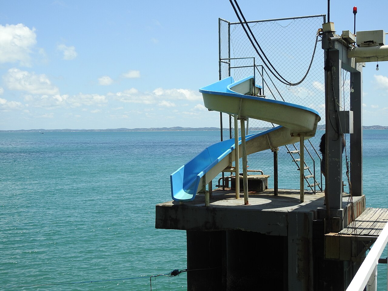
For traveling athletes looking to extend their stay in Salvador, the OCEANMAN SALVADOR BAHIA - BRAZIL 2026 takes place just three kilometres down the shore only seven days later, making it possible to combine both events in a single journey. The Mahi-Mahi venue offers an uncommon start for open water racing in Brazil, operating from a fixed pier and swimming deck perched over deep water. Because the platform drops straight into considerable depth rather than a gradual sandy shallows, the venue requires competitors to be confident swimmers capable of handling open depth from the opening stroke. Any initial apprehension about jumping straight into deep water is quickly dissolved by the environment itself: the sea here is calm, transparent, and remarkably clear, offering complete underwater visibility and eliminating the struggle of pushing through incoming breakers.
Swimmers can take on an introductory 250-metre dash, middle-distance circuits of 750 metres and 1,500 metres, or the premier 3,000-metre test across the open bay water. In past editions, swimmers have navigated these bay loops under pristine visibility, turning around floating marker buoys before returning to the pier deck.
Bay of All Saints: sheltered waters and the ocean divide
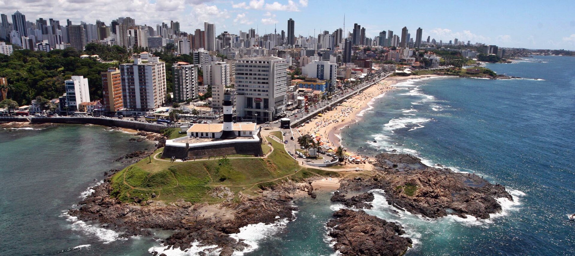
Salvador owes its contrasting aquatic conditions to geography, perched on a long peninsula bordered by the Bay of All Saints to the west and the open Atlantic Ocean to the east. The Mahi-Mahi pier sits on the western flank of this divide, looking into a massive protected marine basin rather than the exposed Atlantic. Inside the bay, the sea behaves gently, spared from the heavy ocean groundswells that pound the outer coast. Along this sheltered bay shoreline, coves such as Praia do Porto da Barra provide small, calm inlets with mild currents that are ideally suited for swimming. Beneath the surface, vibrant corals and thriving marine life draw both freedivers and scuba enthusiasts into the clear shallows.
This protected body of water has long anchored Bahia’s open water racing heritage, serving as the traditional arrival beach for the crossing from Mar Grande into Salvador. Turn past the southern tip of the peninsula, however, and the water changes character completely as the coast meets the open Atlantic at Praia do Farol da Barra. There, between the Santo Antônio da Barra Fort and the Morro do Cristo, waves roll in from the open ocean, producing surf near the hill while natural offshore reefs trap seawater to form quiet bathing pools during low tide.
Ladeira da Barra and the fortresses of the bay
The maritime story of the bay began long before formal colonization, marked by a French shipwreck in 1510 whose surviving crew included Diogo Álvares, known as Caramuru. By 1536, Francisco Pereira Coutinho established the settlement of Arraial do Pereira along the slopes near today's Ladeira da Barra. Then, on March 29, 1549, Tomé de Sousa sailed into Ponta do Padrão in Barra with a fleet of six vessels to establish Salvador as Brazil’s colonial capital. Today, a six-metre stone landmark stands right on the sand of Porto da Barra to commemorate that landing. At Ponta de Humaitá, the Forte de Nossa Senhora de Monte Serrat was erected in 1583 to defend the northern water approaches to the city.
About five kilometres from the race venue, the Forte de Santo Alberto was constructed on the beach between the lower city and Itapagipe to safeguard vessel anchorages and the freshwater supply at Água de Meninos. During the Dutch invasion in 1638, the fort was used to protect the invading camp from the beach side. Rebuilt by 1694, the fort was documented in 1863 as an irregular hexagonal structure equipped with seven cannons, three of which pointed directly toward the sea. On July 2, 1823, it fired the historic cannon shot that authorized Portuguese forces to depart Brazil, though subsequent harbor expansions eventually separated its stone walls from the water. The Battle in the Bay of São Salvador took place about 14 kilometres away on March 3, 1627. In that engagement, Dutch naval commander Piet Pieterszoon Hein sailed into the bay against a fleet of 34 vessels, successfully capturing between 22 and 25 enemy ships in the roadstead.
Barra and Rio Vermelho: ocean coves and sea rites
On the eastern, Atlantic flank of Salvador, the shoreline unfolds into a series of open beaches, rocky outcrops, and tidal pools. Between Farol da Barra and Ondina lies Praia do Cristo, where patches of fine sand nestle among rocks and calm natural swimming basins formed by the tides. Just beyond, Praia de Ondina begins past the Barravento restaurant near Morro do Cristo and stretches toward Clube Espanhol, offering crystalline Atlantic waters well suited for swimming and diving. Low tide transforms Ondina by exposing sheltered natural pools across the rocky bottom, while further north toward Rio Vermelho, a protected cove allows swimming at low water before filling with surfable waves as the tide rises.
Continuing northeast, Praia de Amaralina fronts the open Atlantic Ocean, where a natural carpet of algae blankets the coastal sand during specific periods of the year. Tucked several metres below the promenade of Avenida Oceânica, the small cove of Paciência provides a dual-purpose refuge, shifting between a calm swimming spot and a surf break depending on the tidal flow. Every year on February 2nd, thousands of people gather at Rio Vermelho to cast offerings into the open Atlantic for the sea festival of Iemanjá.
Sources: Salvador
Course
Ultramarathon distance from Itaparica to Mutá.
Awards
Refer to the official regulation PDF for award categories.
Previous editions
Since 2011
How to get there
Circuito Maratour 2026 — Mahi-Mahi (Salvador)
Frequently asked questions
- When was the last edition of Circuito Maratour 2026 — Mahi-Mahi (Salvador)?
- The last edition of Circuito Maratour 2026 — Mahi-Mahi (Salvador) took place on March 28, 2026.
- What distances does Circuito Maratour 2026 — Mahi-Mahi (Salvador) offer?
- Circuito Maratour 2026 — Mahi-Mahi (Salvador) offers 250 m, 750 m, 1.5 km, 3 km, and 16 km.
- Where does Circuito Maratour 2026 — Mahi-Mahi (Salvador) take place?
- Circuito Maratour 2026 — Mahi-Mahi (Salvador) is a sea swim. Location: Mahi-Mahi, Salvador, Bahia, Brazil.
- How do I register for Circuito Maratour 2026 — Mahi-Mahi (Salvador)?
- The reference page for registering for Circuito Maratour 2026 — Mahi-Mahi (Salvador) is https://www.circuitomaratour.com.br.
Where to stay
Salvador offers a range of stays, from colonial-style boutique hotels in the Pelourinho district to modern beach resorts near the Mahi-Mahi venue. Swimmers often choose beachfront pousadas in Itaparica for easier access to the ultramarathon start line. Expect to pay between 350 and 800 BRL per night for mid-range, comfortable lodging during the race weekend. Early booking is recommended, especially for the ultramarathon dates in September, as local demand increases significantly.
Things to do nearby
The region is defined by its strong Afro-Brazilian heritage and colonial history. Between training sessions, you can visit the historic center of Salvador, a UNESCO World Heritage site, or explore the local markets for traditional Moqueca. For active recovery, the calm waters around Itaparica are ideal for stand-up paddleboarding or guided kayak tours, which provide a different perspective on the coastline you will be swimming during the event.
Swimmers
Other stages of this series
- Circuito Maratour — Itaparica (novembro)Itaparica, BR
- Circuito Maratour 2026 — Mangue SecoMangue Seco, BR
- Maratour Village ItaparicaItaparica, BR
- UltraMaratour — Itaparica–MutáItaparica, BR
Similar races


Comments
Transparency: some links on this page (stays, flights, experiences, gear) are affiliate links — if you book or buy through them, Omniathlon may earn a commission from the partner at no extra cost to you. As an Amazon Associate we earn from qualifying purchases.